The city
The Danube in Budapest: the river that made two cities one
Tony Denesa – Travel Advisor9 min read
Budapest is a city that had to be argued into existence, and the argument was about a river.
The Danube here is roughly 350 metres wide, deep enough for commercial shipping, and prone to a spring flood that used to be catastrophic. For most of recorded history that made it a barrier rather than a spine: Buda on the hilly west bank and Pest on the flat east bank were separate towns with separate charters, separate guilds and, in the winter, no reliable way between them at all.
Before the bridges
Crossing meant a boat, or a pontoon bridge that had to be dismantled every autumn before the ice came, or — when the freeze was hard enough — walking across the river itself.
None of these worked well. The pontoon closed for months at a time. Ice crossings killed people. And a merchant in Pest who needed to reach Buda in February had no dependable option at all, which is a serious constraint on two towns that were, economically, obviously one place.
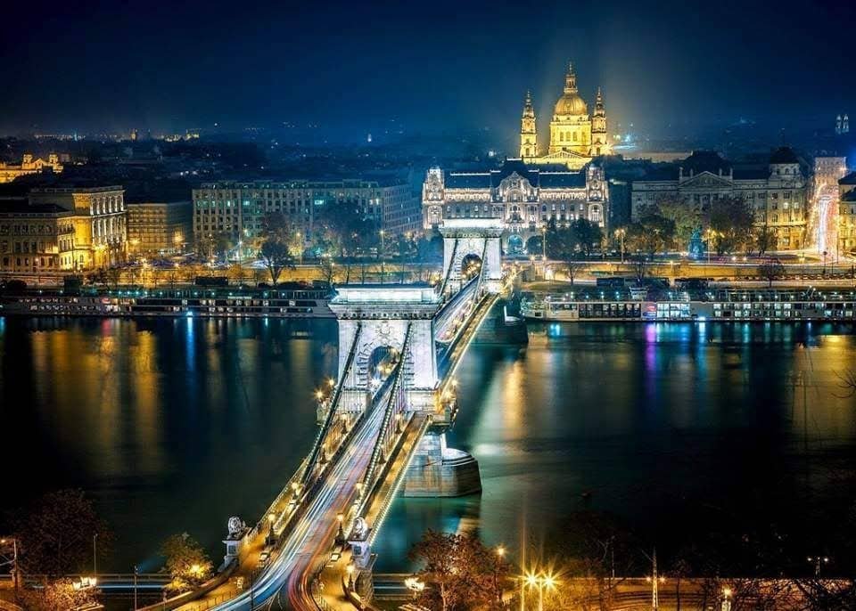
The man who broke the deadlock was Count István Széchenyi, who — the story goes — was unable to cross for his father's funeral and set about fixing the problem permanently. He brought in the English engineer William Tierney Clark to design a suspension bridge and the Scottish engineer Adam Clark, unrelated, to build it.
The Chain Bridge opened in 1849, and it changed more than transport. Under the old order the nobility were exempt from tolls; on the Chain Bridge everybody paid. That small commercial detail is routinely read as the first real crack in Hungarian feudal privilege.
Buda, Pest and Óbuda formally merged into Budapest in 1873, twenty-four years after the bridge.
The flood that rewrote the city
In March 1838 the ice broke up badly and the Danube came over its banks into Pest. The flood destroyed more than half the buildings in the town — Pest was mostly low, mud-brick construction at the time, and it dissolved.
The rebuilding is why central Pest looks the way it does. The stone embankments, the raised quays and the regulated riverbank are all flood engineering, and the nineteenth-century apartment blocks that fill District V went up on ground that had been cleared by water rather than by planning.
What is on the water now
The stretch through the centre — the Buda bank with Castle Hill and Gellért Hill, and the Pest bank with the Parliament — is a UNESCO World Heritage Site, listed in 1987 for exactly the reason it looks the way it does: it is one of the most complete surviving nineteenth-century river frontages in Europe.
Walking the embankment is free and is the best thing you can do in Budapest without paying for it. The Shoes on the Danube Bank memorial sits on the Pest side between the Chain Bridge and the Parliament, marking where Arrow Cross militiamen shot Jewish Budapesters into the water in 1944–45.
Tram 2 runs the length of the Pest embankment and is regularly listed among the most scenic tram routes in Europe. It costs a normal transport ticket and takes twenty minutes.
The islands
The river holds three islands within the city.
Margaret Island is the one visitors use: 2.5 km of park in mid-river, closed to through traffic, with a musical fountain, a running track, medieval convent ruins and the Palatinus open-air baths.
Óbudai-sziget, further north, is quiet for most of the year and then hosts the Sziget Festival every August.
Csepel Island begins at the southern edge of the city; its northern tip is District XXI, and the quiet side-arm along its eastern edge — the Ráckeve–Soroksár Danube — is where southern Budapest swims and rows in summer.
Why the water is warm underneath
The Danube is not the only water here. Budapest sits on a geological fault line where the Buda hills meet the Pest plain, and thermal springs surface along it in quantity — over a hundred of them, feeding the bath culture that has run continuously since the Romans and through the Ottoman period.
That is a separate story, and it has its own page.
Seeing it properly
Three things, in order of effort:
- Walk the Chain Bridge at night. Five minutes, free, and the best five minutes in the city.
- Take tram 2 along the Pest side at dusk, past the lit Parliament at water level.
- Climb to the Citadella promenade on Gellért Hill, 235 metres up, where the whole river and every bridge sit in one frame.
On cruises, a distinction worth making. A daytime sightseeing cruise shows you the same frontage the three options above show you, for considerably more money — skip it. An evening dinner cruise is a different product: it is not sightseeing, it is an evening out on the water with the Parliament lit up, and it is the right answer for an anniversary, for bad weather, or for anyone who cannot manage the climb to the Citadella. Judge them as two separate things, because they are.
The river as a working waterway
It is easy to read the Danube here as scenery, and it is not. It is a working international waterway — the second-longest river in Europe, running through ten countries and four capitals, of which Budapest is the largest.
Freight barges pass through the centre daily. There is a commercial port on Csepel island to the south. And the water level moves a great deal more than a visitor expects: the difference between a low summer and a high spring can be several metres, and in the floods of 2013 the river came within centimetres of the top of the embankment walls at Kossuth tér.
The Palatinus baths on Margaret Island sit low enough that serious floods reach them, which is why the island's paths carry high-water marks.
Swimming, and where people actually do it
Not in the main channel. The current through the centre is stronger than it looks and the traffic makes it genuinely dangerous.
Where the city does swim is the Ráckeve–Soroksár arm — the still side-channel down the eastern edge of Csepel island, past Pesterzsébet and Soroksár — and at the open-air *strand* baths fed by springs rather than by the river. In summer that distinction matters: the Danube is to look at, and the thermal baths are to get into.
Where to stay nearby
Live prices and availability on a map centred on this exact spot — hotels, apartments and hostels, so you can judge the walk from here rather than guess from an address.
Bookings made through this map earn us a commission. Your price is unaffected.